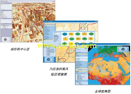
ArcGIS Explorer Desktop是一个由ArcGIS for Server提供强大支持的新的空间信息浏览器;它提供一种免费的,快速并且使用简单的方式浏览地理信息,无论是2D还是3D的信息;并提供了强大的对数据的查询和分析任务。
ArcGIS Explorer Desktop是通过访问ArcGIS for Server提供的强大的完整的GIS功能,整合了GIS数据集与基于服务器的空间处理功能,提供了空间处理和3D服务。ArcGIS Explorer Desktop是也可以使用本地数据和ArcIMS的服务,ArcWeb Services,OGC WMS和KML,具有开发性和互操作能力。ArcGIS Explorer Desktop是可以被任何个人和专业人员下载和使用。
通过ArcGIS Explorer Desktop是,我们可以:
无缝的以2D和3D方式浏览整个世界的数据
集成本地数据以及来自ArcGIS for Server,ArcIMS的服务和数据,OGC WMS或ArcWeb Services
通过任务进行GIS分析,如可视化分析,建模,邻域查找和统计分析
以地图的方式回答跟地理相关的问题,并与他人共享你的结果
使用自有的服务器上的数据和地图,并与其他服务器上的数据联合使用

ArcGIS 10.2新特性全面来袭
-ArcGIS Online功能新突破,迈进真正云PaaS平台
-Portal for ArcGIS开启GIS应用新模式
-ArcGIS for Server具备大数据实时分析和处理能力
-ArcGIS移动产品重磅出击,支持离线编辑和分析
-桌面功能和性能全面提升,大数据支持能力彰显
-ArcGIS三维功能极大提升,与CityEngine深度集成
-影像数据支持显著增强,实现国产卫星影像的支持
-灵活多样的扩展能力和一体化的资源入口
ESRI ArcGIS Desktop version 10.3 with addons | 1.6 Gb
Esri released the new version of AcrGIS 10.3. This major release that will help you discover, make, use, and share maps from any device, anywhere, at any time. ArcGIS 10.3 includes new apps and enhancements that will boost your efficiency and extend the impact of your work in your organization.
Here are some of the highlights:
ArcGIS Pro – Your New ArcGIS for Desktop App
ArcGIS Pro reinvents desktop GIS. This brand new 64-bit desktop app lets you render and process your data faster than ever. With ArcGIS Pro, you can design and edit in 2D and 3D, work with multiple displays and layouts, and publish maps directly to ArcGIS Online or Portal for ArcGIS, making them available on any device.
ArcGIS Pro is currently in prerelease and will be available to you as part of your ArcGIS 10.3 for Desktop license. Stay tuned for the final release in January.
More Tools for ArcMap
At 10.3, ArcMap is better than ever, with improvements such as new analysis and automation tools, infographics capabilities, and tools for managing your data more efficiently. You can even run any version of ArcMap side by side with ArcGIS Pro.
ArcGIS for Server is now a complete Web GIS
ArcGIS Online provides Web GIS, hosted by Esri. With ArcGIS 10.3, ArcGIS for Server delivers Web GIS in your own infrastructure. This is possible because ArcGIS for Server Standard or Advanced now entitles you to Portal for ArcGIS. Portal for ArcGIS unlocks the full suite of ArcGIS apps, including the new Web AppBuilder, so everyone in your organization can leverage your GIS work.
3D begins to roll out across the entire platform
We are continuing to realize the vision of taking 3D information and bringing it to life in browsers and applications that run on devices. At 10.3, we’re delivering a whole new 3D editing and visualization experience for the Desktop with the introduction of ArcGIS Pro. What’s more, you can share the 3D scenes you create in ArcGIS Pro with anyone using ArcGIS Online, which now includes a new Web Scene Viewer. A web scene can have layers, including elevation layers, imagery layers, tiled layers, and feature layers. In addition to viewing scenes created and published using ArcGIS Pro, the ArcGIS Online Web Scene viewer can also be used to create 3D Scenes by mashing up existing layers in your Web GIS, right from your browser. Content that you have already captured can be brought into these scenes and displayed so users can work with that information in 3D.
Over the next few months, subsequent releases will deliver even more 3D capabilities including the ability to publish and disseminate web scenes and layers using your own ArcGIS Servers, including support for sharing photo realistic 3D models (such as detailed buildings), and 3D-enabled mobile applications that work on devices, such as tablets and smartphones.
Real-time GIS at 10.3
At 10.3, real-time, streaming data is fully integrated into ArcGIS. The GeoEvent Extension for Server delivers improved performance with increased throughput capability, faster spatial filtering, and the ability to scale-out by adding machines to a cluster.
A suite of new spatial operators have been added to GeoEvent for even more powerful spatial filtering options, such as intersect, touches, and overlaps, all of which can be applied to any or all GeoFences.
New spatial processors are included, such as Buffer Creator, Intersector, and Symmetric Difference, delivering an unprecedented array of real-time spatial analytics. Even more real-time spatial processors are available in the Esri Gallery on GitHub. You can even create your own.
At ArcGIS 10.3, real-time web maps are here thanks to the introduction of the Stream Service and Stream Layer. Now, real-time layers can be configured, symbolized, and filtered directly in a web map and added to ArcGIS apps and custom applications.
More opportunities for developers
There are different aspects to developing with the ArcGIS platform, and 10.3 introduces new capabilities for developers across the board. First, web development gets better, more powerful, and easier with enhanced APIs, new layers for working with information such as real-time that is streamed into browsers, new visualization capabilities for working with these layers, and new functionality for working with proportional symbols and performing dot density mapping. All of this is available in the JavaScript API and in our web GIS developer model.
Another area that is new in 10.3 is the introduction of Web AppBuilder for ArcGIS, which not only allows users who are not developers to assemble applications, but also gives developers opportunities to build their own widgets that can be used with Web AppBuilder.
10.3 marks the beginning of a wave of releases that will further help developers build mobile applications using ArcGIS Runtime. This will allow developers to take advantage of the same technology that Esri uses to build our mobile applications including Collector, Explorer, and Operations Dashboard. These releases will expose the new 10.3 capabilities for working with 3D, real time, mapping, and offline to developers building native applications for the different mobile platforms.
Last but not least, developers working with ArcGIS Pro can leverage Python to automate tasks. Developers will also be able to extend ArcGIS Pro with add-ins using the ArcGIS Pro SDK for .NET.
What's New in ArcGIS 10.3:
http://pro.arcgis.com/en/documentation/whats_new_in_arcgis.pdf
About Ersi
When Esri was founded in 1969, we realized even then that geographic information system (GIS) technology could make a difference in society. Working with others who shared this passion, we were encouraged by the vast possibilities of GIS.
Today, our confidence in GIS is built on the belief that geography matters—it connects our many cultures and societies and influences our way of life. GIS leverages geographic insight to ensure better communication and collaboration.
As you explore our Web site, you'll discover how our customers have obtained the geographic advantage by using Esri software to address social, economic, business, and environmental concerns at local, regional, national, and global scales. We hope you will be inspired to join the Esri community in using GIS to create a better world.
Name:
ESRI ArcGIS Desktop
Version:
10.3.0.4322
Home:
www.esri.com
Interface:
english
OS:
Windows XP / Vista / Seven / 8 / 8.1
Size:
1.6 Gb
WARNING: Here's the full fix again, this time with x64 Background Geoprocessing workin:
http://filepost.com/files/a34cc3b8/arc103final.rar/
发布日期: 2014-12-15