Blue Marble Geographic很高兴宣布推出Blue Marble Geographic Calculator 这个临时释放功能新工作职能包括区域计算工具和线相交工具,以及在土地调查汇总工作上的改进的文本呈现。
地理空间数据的处理、 可视化和转换解决方案使用全世界成千上万的软件、 石油和天然气、 采矿、 土木工程、 测绘,和科技公司,以及政府和大学组织的地理信息系统分析师。
Blue Marble Geographic Calculator 2016 | 412.3 mb
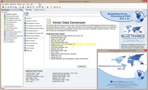
Blue Marble Geographics is pleased to announce the release of the Geographic Calculator 2016. This major upgrade to the industry's preeminent geodetic toolkit offers a redesigned and intuitive interface tailored to optimize workflow and improve productivity. Noteworthy new functionality includes an all-new Start Page providing easy access to all aspects of the software; a reorganized point database conversion function with a unique interface for each variation of the calculation; and improved memory usage for displaying and processing large point databases.
Blue Marble's geospatial data manipulation, visualization and conversion solutions are used worldwide by thousands of GIS analysts at software, oil and gas, mining, civil engineering, surveying, and technology companies, as well as governmental and university organizations.
For over two decades, the Geographic Calculator has been widely acclaimed as the foremost tool for addressing and solving the most complex and demanding geodetic challenges. As the industry leader, this powerful application has become an essential part of the data management toolkit for businesses, organizations, and government departments where spatial data must be accurate and consistent. The Geographic Calculator is used to quickly and efficiently convert, reproject, and transform all forms of spatial data and includes the largest database of geodetic parameters available anywhere. The 2016 release includes improvements throughout all aspects of the software.
The new consolidated Start Page provides an interface for displaying clear and concise explanations for each type of calculation and serves as a launching pad for easy access to the various workflows or jobs. An ideal introduction to the software for new users, the Start Page provides a perfect platform for efficiently navigating the various components of the software encouraging efficiency and productivity. Based on the type of data loaded, the software will now offer a list of the most appropriate calculation operations.
Reorganized menus and updated toolbar buttons have been implemented to facilitate more efficient data processing. The Point Database Conversion job has been split into five logical components: Conversion; Forward/Inverse Calculation; Scale and Translate; Best Fit; and Derive Datum Shift. This simplified approach provides a unique and intuitive interface for each type of calculation.
Additional new features of the Geographic Calculator 2016 include the incorporation of the EPSG version 8.8 into the datasource to ensure the most up-to-date and accurate conversion and transformation results. Point Database handling has been upgraded with improved memory usage allowing larger databases to be displayed. The 2016 release also offers an option to convert multiple columns and multiple coordinate systems in a single operation.
For a complete list of new features and enhancements or to download a trial copy of the Geographic Calculator 2016, visit:
http://www.bluemarblegeo.com/products/geographic-calculator.php
.

About Blue Marble Geographics
Blue Marble Geographics of Hallowell, Maine is a leading developer and provider of software products and services for highly accurate geospatial data conversion solutions. Blue Marble is known for their coordinate conversion and file format expertise and is the developer of the Geographic Calculator, GeoCalc SDK, Global Mapper, LiDAR Module for Global Mapper and Global Mapper SDK. The company has been writing GIS software tools and solutions for over twenty years and currently serves hundreds of thousands of users worldwide.
Name:
Blue Marble Geographic Calculator
Version:
2016
Home:
http://www.bluemarblegeo.com
Interface:
english
OS:
Windows XP / Vista / 7even / 8 / 8.1
Size:
412.3 mb
发布日期: 2015-12-18