鐜板疄涓栫晫鎻愬彇鍗�鏄熷浘鍍忓伐鍏稶nity娓告垙绱犳潗璧勬簮.rar (21.6 MB)
本游戏资料是个关于现实世界提取卫星图像工具Unity游戏素材资源,大小:20 MB ,格式:unitypackage,使用软件:Unity,供广大设计师学习使用,语言:英语,CG数据库整理。
Unity3D是一个让你轻松创作的多平台的游戏开发工具,是一个全面整合的专业游戏引擎。Unity代表了一个质的飞跃——内置的光照贴图(lightmapping)、遮挡剔除(occlusion culling)和调试器。编辑器经过彻底革新,让你可以获得卓越的性能体验。不可思议、无法阻挡的产品已经看到了曙光。
Unity是一款跨平台的游戏开发工具,从一开始就被设计成易于使用的产品。作为一个完全集成的专业级应用,Unity还包含了价值数百万美元的功能强大的游戏引擎。Unity作为一个游戏开发工具,它的设计主旨就是让你能够创建令人惊讶的游戏。如果你之前尝试过Unity,请查看Unity都做了哪些更新。如果你是第一次尝试,那就好好看看吧,看Unity都能为你带来什么。Unity作为一种开发环境,可让你脱离传统的游戏开发方式,以一种更简单的方式专注于你的游戏开发。开发网络游戏、移动游戏、单机游戏,Unity都能完全胜任。
Compatible with Unity 5.1 and higher, 2017.x and 2018.x
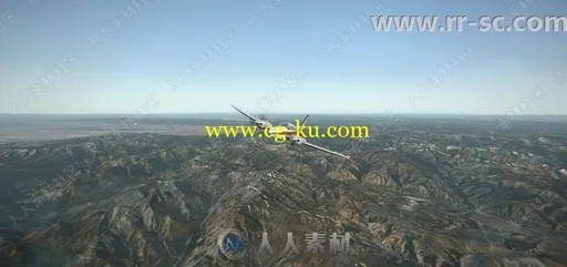
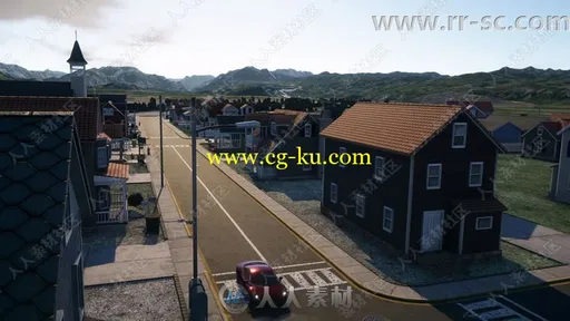
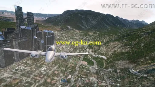
Its powerful features let you create high resolution AAA quality real world terrain with a few clicks.
For a quick overview of the main features I recommend to watch the WorldComposer trailer.
I invented a shadow removal algorithm that can make the satellite images shadow free. Shadows in imagery are problematic and removing them makes a huge difference in terrain rendering quality. Instead of having a fixed sun position to fit with the satellite images shadows, you can have day and night cycles.
Features:
- Works with Unity Pro and Free, also on Mac.
- Elevation Heightmaps resolution of max 10 meter per pixel.
- Satellite images resolution of max 0.25 meter per pixel. Jpg/png/raw format supported.
- Content aware fill to remove shadows, snow, etc. from combined raw images.
- Create huge multi-resolution terrains with different layers of detail. - Combine raw images to 1 big raw image. E.g. for editing in Photoshop.
- Split combined raw file into tiled images.
- Create terrains directly from exported areas with a click of a button.
- 3 different satellite images types, Aerial, Aerial with labels and roads.
- Global coverage.
- Convert ArcInfo ASCII heightmaps to 16 bit raw grey scale heightmaps.
- Create unlimited regions and areas and export any heightmap size or amount of image tiles.
- Export multiple areas.
- Scroll interface like Google maps.
- Exporting is Multi-Thread.
- Automatic version update inside WorldComposer.
- Works with TerrainComposer (as an extension).
- Works with RTPv3 and Horizon[On] (Optional).
现实世界 提取 卫星图像 图像 工具
发布日期: 2018-9-14